Showing posts with label travel. Show all posts

Monday, May 24, 2010

Map Woes Part 4

(...continued from Map Woes Part 3)

A recent visit to the Survey of India map sales office in Delhi was most frustrating. The people there were extremely reluctant to show me any maps without me first telling them the exact sheet number- they probably even need the latitude and longitude- and even then could only give me some large but pretty useless trekking maps of the Gangotri, Badrinath, and Shimla hills regions.

Pic: The impressive looking but ultimately disappointing trekking map from SOI (Bibek Bhattacharya)

They were careworn and mothballed, and the contour maps were kept firmly out of sight. I had made the mistake of going there without the sheet names and they effectively used it against me. And of course there’s that eternal suspicion. Just who is this person, they think. Why does he want topographical maps of border areas?

I had to settle for the trekking maps. Next time I go, I’ll take a sheet of paper with ALL the sheet names I can think of, and then some. And this time, if they demur, I will HAVE to do the unethical thing and wave my press card at them!

But then, a few weeks ago, I found this! I’d heard of it before, but I had no clue that it was freely available.

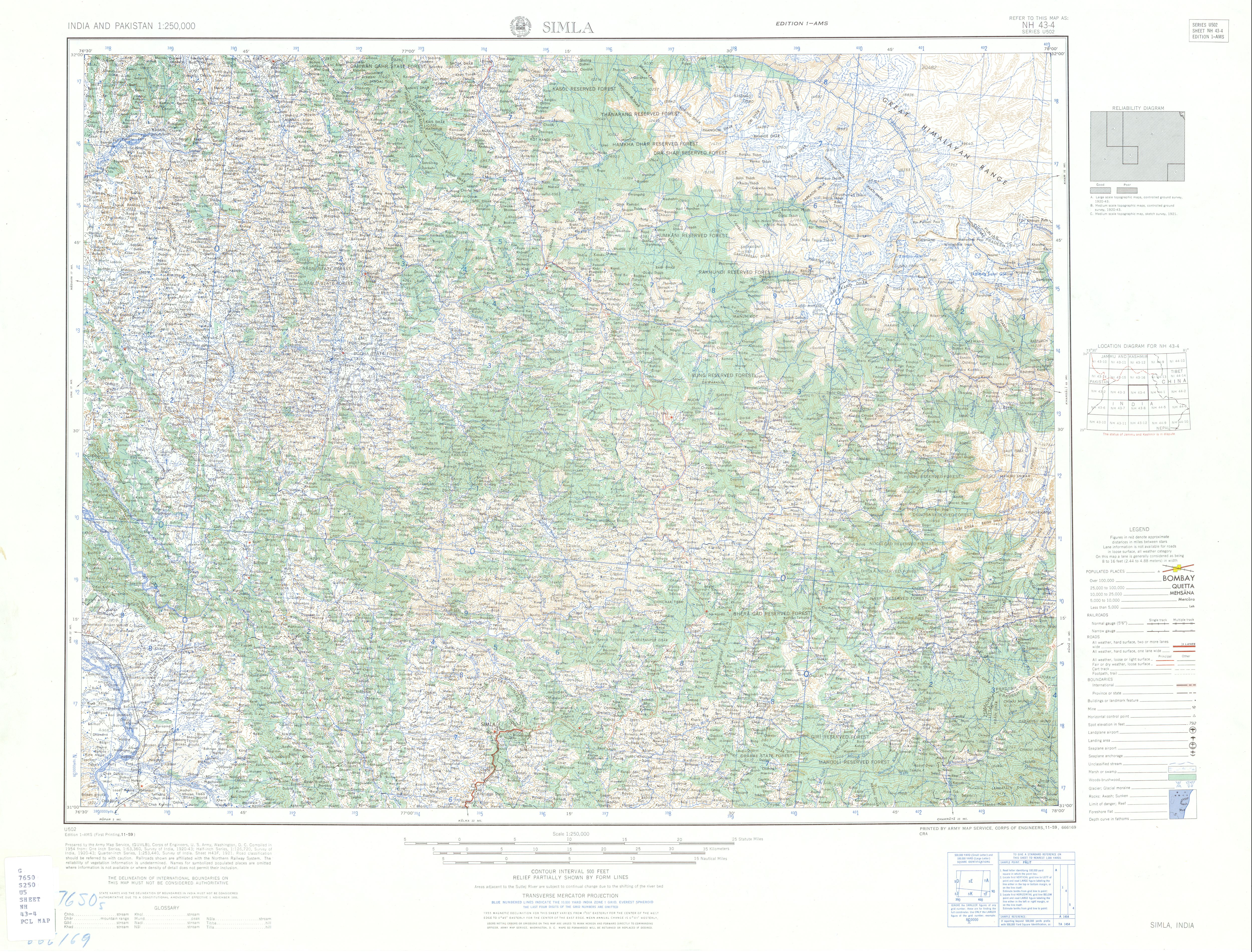
These amazingly detailed topographical maps are the legendary Series U502, made by the US Army Map Service for, yes the US Army, back in 1955. That makes them 55 years old, but boy are they out of this world. These sheets are the real thing- at least in the absence of SOI sheets. And the sheer scope of it is massive too, covering the entire subcontinent, including India, Pakistan, East Pakistan- ah the period piece ring of that- and Ceylon.

From what little of this vast map I’ve seen, most of the Himalayan regions seem to be pretty accurately mapped, at least after checking them against the others. And I can’t begin to describe the joys of learning the names of the many unforgettable places that I’ve seen in the mountains, and all that I’m yet to see. Entire ridge systems, rivers, towns have their names. Now these names might have gone out of use since all those years ago, but many of these I’ve managed to verify. The trend seems to be that of pretty accurate nomenclature.

Pic: The Dehradun Sheet of the AMS Series U502 (Bibek Bhattacharya)

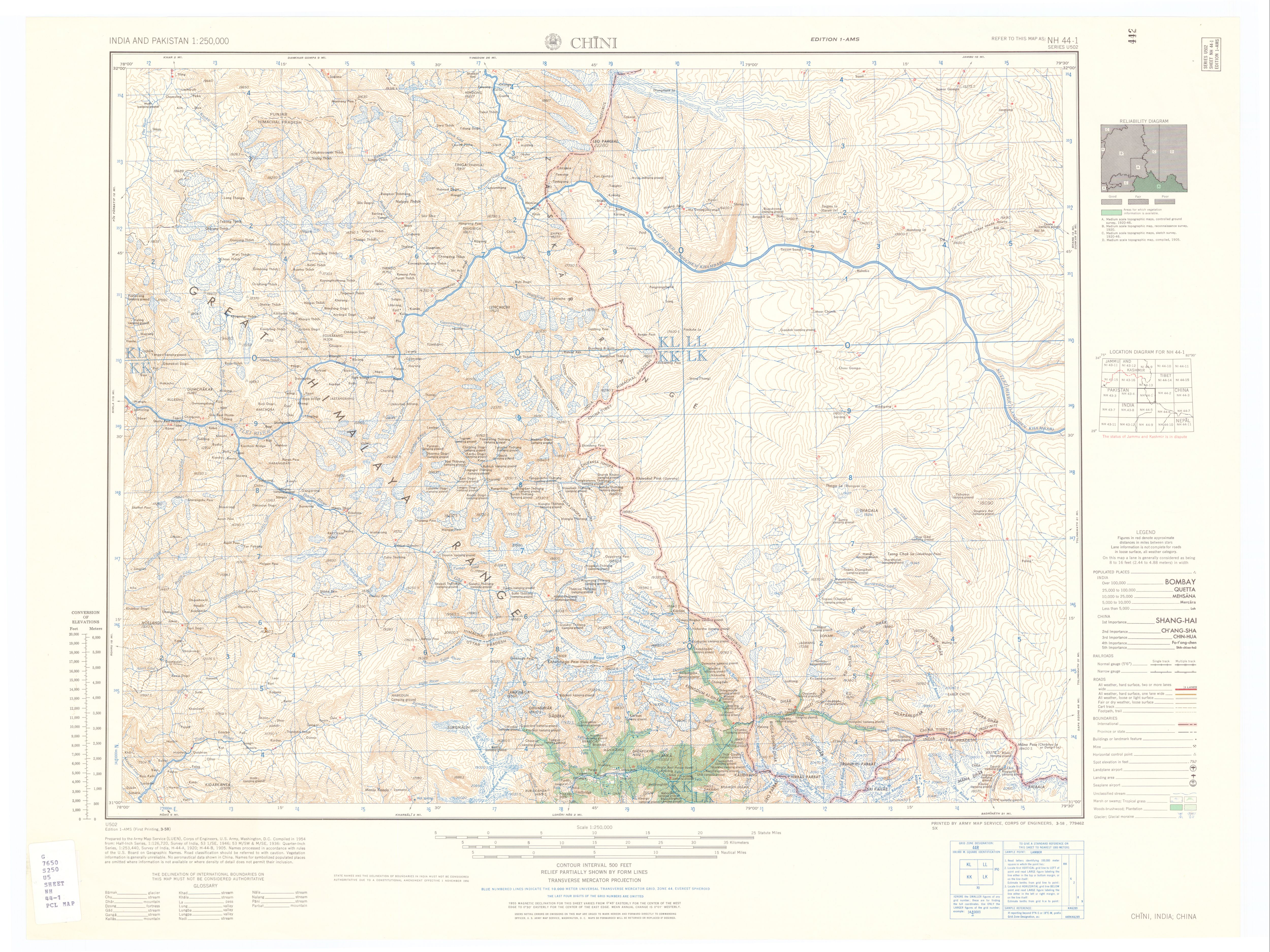
The maps trip up in some places. For example, in the 'Simla' (sic) sheet, there’s a blank spot beyond the Pin Parvati pass where Spiti should be. It could be that the region had not been surveyed at the time. Then there are problems with the deeply contentious Indo-Chinese international border north of Gangotri. According to these maps, the entire Mana Gad (Gad is Garhwali for river) valley and its tributaries belong to China, although a glance through Kapadia’s Across Peaks and Passes in Garhwal gives us the real picture. At the end of the day there is no substitute for actually visiting these places.


Pic: Compare the section of the Chini sheet with Kapadia's map for the Mana Gad area in upper Central Garhwal. (Bibek Bhattacharya)

However, it must be said that where unsure, the Series U502 mentions it. They even have a handy 'Reliability Diagram' to the right of the map, where they rate the available information in that particular sheet from 'Good' to 'Fair' to 'Poor', and even list out the dates when the ground was surveyed. The oldest survey on the 'Chini' sheet, for example, are Medium Scale Topographical Maps from 1905!

Anyway, I’m completely in love. Oh, and finally, to end where I began, I now know the names of the eminences you see when you stand atop Chandrashila on a clear October day. It might be a meager victory, but to me that’s momentous!

And so, my map woes are at an end- at least until I renew the saga of SOI Topographical maps.


IndiBlogger - The Indian Blogger Community

Map Woes Part 3

(...continued from Map Woes Part 2)

So anyway, I went to McLeodganj shortly after that year, and in a small bookshop near the Dalai Lama’s monastery, I found two sheets of the Leomann Map series, these ones dealing with two of Himachal Pradesh’s regions. I was dumbstruck by their detail. There were clear ridge-lines and marked glaciers, all possible landmarks and trails, as well as most of the peaks en route. Leomann maps are, so far, the most comprehensive all-in-one set of maps of the Himalaya that I’ve come across.

Pic: Leomann Maps Sheet 4 (Bibek Bhattacharya)

After such knowledge, what forgiveness?

However, in the year and half since then, I’ve scoured bookshops and chat groups wherever I can and haven’t come across any other Leomann map. To get the full set, the only recourse to order the lot online, which I can't afford, especially with the shipping costs.

Over the past year, I’d amassed quite a few books on trekking trails, which included two quite good ones- Trekking Guide to the Western Himalaya by Depi Chaudhry and the legendary Harish Kapadia’s Trekking and Climbing in the Indian Himalaya. Both have excellent maps, although Kapadia’s book shades it, purely because he’s been all over the place and knows the terrain like the back of his hand.

This year I discovered Flipkart, and thanks to their wonderfully no-nonsense attitude to online book shopping, I was soon drowning in mountain books- and maps. The combined heft of Kapadia’s Across Peaks and Passes Garhwal Himalaya, Kumaon Himalaya and High Himalaya Unknown Valleys added some remarkable maps to my collection. Sadly, his books are horribly edited, but even bad editing can’t dampen Kapadia’s enthusiasm for the range, nor negate the sheer amount of distance that he has covered in his forty years of mountaineering. His maps are among the best I’ve seen so far. They tell you everything you need to know, and there are never any gaps in the information. They have detailed ridge lines, rivers, prominent landmarks, watershed ridges and are almost exhaustive in naming peaks in the regions.

Pic: Harish Kapadia's remarkably detailed maps (Bibek Bhattacharya)

As an aside, anyone interested to get their hands on some good writing on the range should get a hold of Bill Aitken's The Nanda Devi Affair and Footloose in the Himalaya. Both are, again, the victims of horrid editing, but Aitken's a particularly fine writer, and his passion for the range, coupled with his acute observations and charming eccentricity, make both books a must read.

Thanks to Kapadia's exhaustive maps, here was something that I could use in tandem with Google Earth to get a visual sense of the terrain in every Himalayan region. The joys were many, from charting out all possible peaks in central Garhwal- and thus solving the many mysteries of the view from Tunganath- to tracing out the more challenging trekking routes, like that from Chitkul in the Baspa valley over the Himalayan divide between Himachal and Garhwal over the glaciated Lamkhaga Pass to Harsil near Gangotri.

But proper contour maps still eluded me.

(to be concluded)

IndiBlogger - The Indian Blogger Community

Monday, May 17, 2010

Map Woes Part 2

(...continued from Map Woes Part 1)

So I looked for other maps. Some of these I found in books, and the information I tried to locate with the help of GE as well as Wikimapia (which is better marked but not always trustworthy). It’s a painstakingly slow process, but at least I was making progress.

The Eric Shipton Anthology possessed his superlative book Nanda Devi, which had a reasonably good map (which was great to get my bearings) of the Nanda Devi-Bhyundar- Joshimath-Badrinath-Madhmaheshwar area; basically central Garhwal.

Pic: Central Garhwal Himalaya from Shipton's Nanda Devi (Bibek Bhattacharya)

An infinitely better plotted set of maps soon emerged out of mountaineer and photographer Kekoo Naoroji’s book of photo essays Himalayan Vignettes. It also had a very good set of maps of Western Sikkim, the area around Kanchenjungha and Nepal Gap glacier. What’s more, the book also included sizable chunks of lower Garhwal.

Pic: A plate from Kekoo Naoroji's Himalayan Vignettes (Bibek Bhattacharya)

A third resource was Frank Smythe’s book Valley of Flowers. That book has some nice trail maps, especially of the classic Garhwal “approach trek” from Gwaldam to Joshimath via Kuari Pass and of his explorations around the Bhyundar Valley.

Pic: Map of the Bhyunder-Kamet region in Central Garhwal from Smythe's Valley of Flowers (Bibek Bhattacharya)

The problem with this was age. It was written in 1938- he made the journey in 1937- and that area was only in the process of being properly surveyed, so names of lesser peaks, glaciers and villages wasn’t exactly fixed. But it felt great to compare maps and accounts of these early writers- for a profoundly Indian point of view of the Uttarakhand Himalaya in that era, see Umaprasad Mukherjee's travelogues.

Pic: Map of the Gangotri Glacier region from Umaprasad Mukherjee's travelogue (Bibek Bhattacharya)

Needless to say, I was devouring all this.

But I longed to get my hands on some serious maps of the Western Himalaya. Being quite hidebound as well as anal in my pursuits, I especially looked out for maps of Uttarakhand, as this was the region I wanted to explore first.

(to be continued)

Saturday, May 15, 2010

Map Woes Part 1

Trying to find good trekking and topographical maps in India is somewhat like the proverbial head meeting the proverbial wall. My year of looking for the perfect set of maps- primarily of the Indian Himalaya, but also of other places- has yielded very interesting results.

I love travelogues, especially those dealing with mountains, specifically the Himalaya. Now due to the range's monumental hold on generations of visitors, there’s no short supply of great books or essays on this subject. But for an obsessive like me, what’s the fun in reading about these grand places without a good map to locate them on?

The most commonly available maps of Uttarakhand and Himachal are the Nest and Wings maps, which are a combination of various sources, including the Survey of India trekking and topographical maps, and others. Now, these are generally quite good, with towns, cities, villages, passes, roads, lakes, trails etc mentioned in impressive detail. For the longest time, they were enough for my needs.

Pic: A section of the Nest&Wings map of Uttarakhand

But with a deepening interest came the urge to collect better maps, which would chart out valley systems, topographical features, ridge lines, peaks and approaches better. Now, this isn’t an unfair thing to expect. Look up any mountainous region in the world where travelers are wont to venture, and you’ll find some excellent trekking maps- not the meagre ones that our government issues, but more on that later.

My search began in earnest last summer, after a visit to Tunganath and Chandrashila in the high Garhwal Himalaya, a place with views that make you want to sink to your knees and weep with rapture. Faced with the dramatic panorama of the Himalayan crest on the northern horizon, and the lower hills and then the plains far away, I was burning to lend nomenclature to all that I was seeing. Thanks to Nest and Wings, I had a general idea of the regions I was looking at- e.g. I could trace roughly the line from Bedni bugiyal via the high distant ridge of Kuari Pass in the west and below it, the deep cleft of the Alaknanda gorge. Where mid-day clouds covered the horizon, I expected the western arm of the Great Himalaya, containing the likes of Trishul, Nanda Devi, Dunagiri, Hathi Parbat, Ghori Parbat and Kamet, to name a few.

Pic: Nanda Devi looking west from Chandrashila (Bibek Bhattacharya)

In front of me, just beyond the end of the ridge running north from where I was, the cairn strewn summit of Chandrashila, loomed Chaukhamba. It is also known as Badrinath, after the Dham, and these four pillars of snow, ice and granite held sway over the imagination of Garhwal.

Pic: Chaukhamba looking north from Chandrashila (Bibek Bhattacharya)

On its northern face it formed a cirque of peaks at whose feet arose the Gangotri glacier. Further north west ran the line of the southern faces of a host of well known peaks that cluster around the Gangotri Glacier.

It was impossible, however, to be sure of the names of the peaks- apart from those of Kedarnath and Chaukhamba- at least for me. Having recently discovered Google Earth, however, I was hopeful of finding out the names.

Pic: An overhead screenshot of Uttarakhand Himalaya

Google Earth was quite brilliant, visualizing the peaks for me, but they weren’t named, at least the vast majority weren’t. In this case, Nest and Wings was useless.

(to be continued)

IndiBlogger - The Indian Blogger Community

Friday, October 09, 2009

Chandrashila

I sat beside a cairn atop Chandrashila watching clouds rise. Freezing in Sujaan's choti at Tunganath, a combination of sleep deprivation and oxygen depletion had effectively ruled out my much cherished ambition of making it to the peak before sunrise that day. Feeling a little better as the day wore on, I decided to make a try for it. After all, it was a beautiful sunny day.
At Tunganath, the weather changes every ten minutes. This a local saying, and absolutely true. I definitely didn't want to tempt the weather while the sun was still shining. So I told Biru to wait a bit for Sujoy and Debo- the friends I was travelling with- to wake up and struck off on my own. I had last climbed it in May this year. I was way fitter then, so I had very little hopes of making it up there without huffing and puffing my lungs out. As it turned out, the mountain paid me a huge compliment. Probably because I was a lot better used to breathing on this altitude, even with stops to make calls to people (high up the peak I was getting a signal from Gopeshwar on the other side of Chandrashila!) and admire the scenery, I still managed to get up there in half an hour. I was about to ring the bell at the tiny temple of the moon, when I happened to look beyond, and time literally stood still. Far away, yet strangely near, on the North Eastern horizon rose a gaggle of sharp peaks.

Pic: Nanda Devi and her sisters hold court on the far horizon
Two I could immediately recognise because of their distinctive shapes- the mighty Nanda Devi, and Hathi Parbat, the presiding peak of the Bhyundar Valley.
The temple was forgotten. Mindful of the fact that soon either my camera's going to freeze or that the batteries are going to give up, I quickly took as many snaps of this magnificent scene as I could. In the not-quite-noonday sun, the distant white peaks look like translucent chalk sketches against a blue 3D sky. Needless to say, it was unlike anything I'd ever seen before, except maybe in some dream.
The immediate patch of rocky ground behind the temple (the highest point on the peak) is covered with cairns. These vertical structures of various sizes are made from slabs of stoes from the peak and seem to be constantly made and re-made. In May I had asked Biru what these structures signify and he'd said that these were memorial stones. To my fevered imagination they look more like portals into some other world. Amongst them, a Japanese man was singing.
It was a surreal sight. This middle aged man had planted his walking stick upright, slung his thick ski jacket and hat over it, and was lying in its shade reading a book, and occasionally breaking out into song. He grinned at me and went back to reading and singing.

Pic: A Japanese sun-worshipper on Chandrashila

A few feet from him, at another part of the peak behind some other cairns, another of his compatriots was sitting still in a lotus position with his face towards Nanda Devi, deep in meditation. In all there were three of them. I was to bump into them over the next few days, either meditating on tatami mats on the peak, or wandering about wearing a lost look in Tunganath, where they were staying at a different choti.
Making sure that I wasn't disturbing them, I plonked myself down on a rock face overlooking a deep precipice. Down below, through the haze and rising wisps of clouds I could see the wooded valley that had so caught my fancy the last time I was here. In front of me, still visible clearly, rose the distant panorama.
It felt just so exhilarating to finally see Nanda Devi, unencumbered, in all her glory. The other time I'd seen her, it wasn't this sideways view. Rather I'd seen her head on, part veiled by the Mai ki Toli ridge, but with both her twin peaks visible. This was from the Binsar sanctuary in the Almora hills of Kumaon, from where its much closer. From the peak though, she looked serene, detached from the dramatic, wild beauty of her environs. Its easy to see why people revere her so.
But my view of her and the other distant giants depended purely on the whim of the clouds. By nine thirty, the day's heat had had its effect on the sub-tropical climate in the valleys which were giving rise to a succession of little pillow like clouds. While many dissolved in the cooler air above, many more started to form little gangs, which then became bigger gangs.

Pic: Cloud-eye view

Clouds change shape better than any con artist. Constantly forming, disintegrating, reforming, flowing into, out of, over and around ridges, they form an elaborately graceful ballet of carefully choreographed chaos. And so they roamed about me, avoiding this high peak, but erecting and dismantling teasing curtains between me and the distant peaks. So every now and then, all evidence of the far vistas would vanish, leaving me to wonder at what I'd seen. The first time Nanda Devi was cloaked, two Monal took wing, circling overhead while uttering mournful cries, as if in her memory. Then there were the giant Himalayan Gryphons, their backs glinting in the sun, gliding from one air current to another, circling the upper air. They seem totally at home, yet impervious to the beauty of the place.

Pic: Massive Himalayan Gryphon flying high

As the sun climbed higher, the ever present buzzing of large , laggardly flies increased. I'm absolutely not well informed on insects, but the sheer variety I saw on this lonely peak was breathtaking. And then there were ravens. Massive black birds, graver and more ominous than your average crow. They seemed to be constantly watching, flying from one impossible rock overhang to another, squawking, and making these strange half conversational sounds. They are mysterious birds, who indeed hold parliaments when there is a quorum. I can't think of a more appropriate word to describe a group of these birds.
When there was nothing to see, I simply closed my eyes. Immediately my ears pricked up. The wind blowing; a sensation of cool moisture on my cheeks; rustling, buzzing insects; an occasional avian cry. But above all, silence. Every now and then, a sound from a distant village, many thousands of feet below. Startling and funny, like rocks talking to each other.
After a spell, I opened my eyes, and the clouds had shifted. I could see Nanda Devi and her sisters holding court again in the bright sunshine. To my right, above the great green valley that leads to the Anusuya Devi temple in the jungle, huge plumes of clouds were forming. In front of me, due north, Neelkanth was suddenly revealed in all her glory. Further North East small tufts of clouds hung in the air between Chandrashila and the Kedar Massif, casting little shadows on the rich bugyals (high altitude meadows) below the range. At moments like these, I stared in vain at my notebook, struggling to find words evocative enough to describe this beauty. I smiled to myself, imagining the poet Coleridge on this peak, startled out of his opium haze into a fresh appreciation of the sublime. He was a staunch lover of mountains, sometimes recklessly so. One one occasion, he managed to get himself trapped in an impassable grotto in the Lake District. With dusk coming on, and risking exposure, he decided to shut his eyes, take a deep breath and will his way out of there. Opening them, he realised that there indeed was a way- through a difficult and dangerous rock scramble. Sure enough he did. A fascinating story. My guess is, he'd have loved this place.
Bang in front of me, between Chandrashila and Neelkanth, rose a bleak naked rocky ridge, which the local people refer to as kala paththar. An evocative enough name. Back in May, it was covered in snow and ice, but now there were just rocks, and the occasional huge gash signifying the path of a winter snow-field. But it says something about the enormity of the geography here that these same locals believe that there's nothing there. Wrong. Behind and beyond that ridge lies Nandi Kund, an enormous lake from which rises the Madhyamaheshwar Ganga, as well as the huge green hanging valley of Pandosera. That way lies a high track that crosses a couple of high passes under the toe of mighty Chaukhamba to gain access to the Bansi Narayan temple on a massive ridge further to the East overlooking the Alakananda Valley. According to Biru, many sheep-herders often go that way, as do other local people to collect Bramhakamals or the huge lotuses that the high Himalayas are famous for. Someday I'll get to see the place, I hope.

Pic: The forested river valley below Chandrashila, with a snow covered Kala Paththar in the background.

Chandrashila is the highest peak on a long, high and incredibly serrated ridge that runs south to north from the forested valley of Chopta to the highlands below Chaukhamba, running parallel to the Sari and Madhyamaheshwar ridges. Some of the other high ridge-points that I'd been climbing over the last few days with Biru now lay below me- awesome mountains in their own right, but somehow dwarfed by their magnificent setting. As I gazed, some ravens took wing, circling lazily in the morning haze.
Through all the shifting weather, the four white pillars of Chaukhamba rose imperiously, as if above human concerns, glinting severely yet reassuring in the sun. To think that just behind its massive ramparts lay the Gangotri glacier and all those fabled peaks.

Pic: Chaukhamba

Some of them I could see from there- Thalay Sagar and Shivling, beautiful spires both, are visible slightly behind the Kedar Massif. Then come the peaks of Meru, Mandani, the Bhagirathi group. Many peaks, of which I am not sure of the names. In those fabled lands had travelled both my heroes- Eric Shipton and Umaprasad Mukherjee. Both had also come here. In his journal on the 1934 Nanda Devi expedition and the subsequest crossing of the Kedar-Badri watershed under Chaukhamba, Shipton wrote about a zig-zag high altitude pass he took to get to Chamoli back on the way to Joshimath on the road to Badrinath. There it is below me, rushing down the eastern face of Chandrashila on its way down to the forests of Mandal to join the motorable road to Gopeshwar and Chamoli.

Pic: The old pilgrim trail

Mukherjee made special mention of this pass, extolling its natural beauty and bemoaning the unwillingness of pilgrims to take this harder but more enjoyable old route just because there was a tarmac road passing below through Chopta. He was writing in the early 60s. Now, it has fallen even more into disuse. While in the dry cold weather of May, I could easily make out the contours of the path, now in verdant October, just a memory of the path existed. Mukherjee was a deeply religious man, but even he acknowledged that the true reward of making the long and arduous climb to Chandrashila was this view of the high peaks. Amen.
This land is so old. It fills you with a deep awe that's beyond simple religiosity. As I sat in that private paradise of mine, I prayed that I'd never forget it.

IndiBlogger - The Indian Blogger Community

Thursday, October 08, 2009

Good Day Sunshine!

Jumping out of bed at the cold, unearthly hour of 4:30 am I stepped out in the freezing night to have my breath taken away by the galactic arm of the Milky Way stretching over me. But I hadn't much time to lose, as I had to get to the peak of Chandrashila by 6 am or miss the fabled sunrise. So I ran in the lightening darkness, my lungs heaving with the effort in the rarefied air and my head spinning with the cold and the exertion. Behind me the Chaukhamba and Kedar peaks brightened in the fast-approaching dawn. Ahead of me, on the ridge-line the silhouettes of other sunrise-spotters intent on their goal, trudging up. One by one I overtook them, my head spinning. Below and behind, I could see a torchlight in the darkness- Debo and Biru coming up behind me.
A loud yell of exhilaration escaped my throat as I rounded the last hump and came up in front of the temple of the moon atop Chandrashila. The sky had cleared behind me, though Chaukhamba and the other giants had yet to catch fire. I made my way through the gaggle of people on the peak to the farthest point on the ridge. This is what I saw, over a half hour that lasted forever. Night below me and daybreak at 4,100 m. The sun came out slowly, like a grand comedian with impeccable timing, behind the beautiful spire of Nanda Devi.


IndiBlogger - The Indian Blogger Community

Saturday, September 19, 2009

The love of mountains


Durga Pujo is around the corner. When I was a kid, the very thought used to make me go weak in the knees with happiness. Tired as I grew of it, Cal's pujo is still something to behold. In my opinion, it is the closest one comes to a carnival in this country, apart from the actual Goa carnival of course. Great memories, happy memories.

Right now, all I can think of is one thing- going to the mountains. If anything can be said to have usurped Durga Pujo's place in my affections, it has got to be the mountains. In fact, the joy I get from altitude far outstrips my childhood fondness of Pujo.

Why? Well lots of reasons really. But if I were to really put my finger on it, it would be this- the Himalayas- and other hills and mountains- are the only places which are truly spiritual to me. I mean, to walk for hours up or down mountains, through the humming quiet of the roads and forests and rocks and fields; to see geography crumpled up and refashioned on such a gigantic scale; to see the high peaks glistening unimpeachably in the sky, and to look down to see deep blue valleys emerging as if out of some primordial dream of belonging- that is the closest I come to any sort of religious epiphany. I mean, if the beauty of the land can bring tears to your eyes, isn't that something to cherish? Outside of the Bengal-Bihar countryside, where I grew up- no other place affets me as deeply.

Hence, not a month goes by without me feeling eternally grateful for my life- to be able to live and work in a place from where the mountains are just six hours away; and the high Himalayas a mere 14 hours.

My parents travelled ceaselessly, or so it seemed to me as a child. From our home in Purnea in North East Bihar, Siliguri via Kishanganj was only a six to eight hour drive away, so I'd been going to Darjeeling from the age of two. Puri was the other favourite, us being Bongs, so many a holiday was spent there as well.

But some of my favourite trips with my parents has been to the mountains. I remember the December jaunt to Manali- my first snowfall!!- in 1996 and the absolutely superlative Kedarnath-Badrinath trip of 1999. That's when I really started to see the mountains as something beyond the promise of cool climes and snow peaks. The sheer sensory experience of the Garhwal was something. I'll never forget the Kedarnath massif rising out of a cloudy dawn behind the temple of Kedarnath, or Nilkantha floating like a shark's tooth in the air above Badrinath. But it wasn't just the peaks. What I loved best was the journey to get there.

Kedarnath from Gaurikund was the first trek of my life and quite unforgettable. You start among the thick forsts of Gaurikund, and over the next 14 km, you rise up inexorably to finally emerge into the high valley above the treeline, springy turf under you and exhilirating vastness all around you.

While in college, me and some friends made our way to the Valley of Flowers in 2001. A magical land if I've ever seen one, this was high altitude all right, and I realised that the Himalayas are a most happy addiction.

Imagine my plight then, when for five long years various circumstances kept me apart from my love. Only in 2006 could I go again, this time to Mussoorie. I was aghast to find the same spoilt Delhi brats whining in a Cafe Coffee Day store on the Mall Road, but heck I could not argue with the bits of clouds playing hide and seek with me around the lush mountains of Tehri Garhwal.
Another long wait of two years. By 2008 I'd had enough of all this dicking about in the city, trying to earn a livelihood and all that. So I took off to McLeodganj to meet my friend KP who was staying there. Took another friend of mine, Debo, along.

Pic: Dharamshala and Kangra Valley shrouded in clouds, seen from McLeodganj

This was it, mountain madness had finally caught up with me and had claimed me for its own. In fact I can pinpoint the moment when it happened. The first was when I awoke at dawn on the bus to Dharamshala to find us in the middle of the Shivalik highlands of Himachal Pradesh, going past a beautiful river, on the way to Kangra. In the distance, through the clouds I could see the giant ramparts of the Dhauladhars sweeping up to the sky. At that moment, I knew exactly what I'd been missing all this time.

Pic: Triund, on the ramparts of the Dhauladhar Range.

The second moment came a few days later. Debo had returned to Delhi, and me and KP were making our way up to Triund on the shoulders of the Dhauladhars, on the way to Indrahar Pass.

Trekking up after so many years with a spoilt body full of smoke and repose was always going to be hard. The fact that I was shit stoned didn't help much either. In fact, considering the difficulty, I insisted on getting even more high, and KP was only too willing. Half way up Triund, at around 2 pm or so, wheezing and pulling my tired, screaming legs up the next boulder with my heart threatening to jump right out of my body, the clouds which had surrounded us for much of the trip burst and rain came pouring down. My predicament just got worse. Not only did this meant that the going got even tougher, as veritable rivers of mud were flowing down the quagmire of a track but my dope paranoia made me imagine that the mountain was for some reason trying to shrug me off its back. Still, we kept trudging, past immense boulders and even larger dead tree trunks in a shadow land of cloud, thunder and rain. Finally, after what seemed like an eternity, we came around a bend and-Triund! A high altitude meadow, with a gentle mist hanging over it and myriad little flowers blooming in the grass. That's when I was convinced that this was the life for me.

Fortunately, that trip pretty much opened the floodgates. Next I went to this place called Viratkhaai above Chakrata in Western Garhwal for an adventure sport camp. I lost a tooth falling off a bike and got ravaged by leeches, but the place was magical.

Pic: The Yamuna coming down from the mountains north west of Mussoorie.

The monsoon had just hit and the various valleys were wrapped up in a shroud of mystery, as our Press bus went up along crumbly roads over horrid precipices up to the camp, past beautiful waterfalls and entire river systems swollen into floodwaters thanks to the incessant rain.

Pic: Mountains of Tehri Garhwal at Dhanolti near Mussoorie.

Next I went to Mussoorie again, which was pleasant. Come October, and I was off to Bhuira, this charming hamlet in the Shimla hills of eastern Himachal.
Pic: A cairn atop a hill in the Shimla hills near Bhuira

While there, us friends trekked up this local hill top. Crisp in the fall sunshine, I tugged at my beard and spaced staring off into the middle distance.

Early this year, in March, while it was still cold enough to discourage tourists, me and a friend of mine, Priyo went off to Binsar, a forest sanctuary above Almora in the Kumaon hills. Having missed a bus, and then having travelled for a full 12 hours through North UP (hell on wheels), when we woke up to a stunning Himalayan panorama (pic below) it was all worth it.

Pic: Nanda Devi and other giants at dawn, seen from Binsar.

Each and every moment of my time there was sublime- whether it was staying in a century-old forest guest house in the middle of an oak and rhododendron forest with some immense cedars for company, or the sight of the majestic Kumaoni peaks- Trishul, Nanda Devi, Nanda Ghunti, Panchachuli among them- or a fabulous trek of some 20 km through the beutiful valleys and ridge-tops of the Almora hills to the ancient temple town of Jageshwar from there.

Another trip to McLeodganj followed in April. This time there were quite a few of us, and the pace was less frantic. Indeed, for once, I was happy not to try and cover too much ground and just relax instead (I still forced them up to Triund though!).

Then in May, on my birthday along came the big trip to Tunganath and Chandrashila, again in the Kedarnath mountains of Garhwal.

Pic: The high Himalayas of north Garhwal, Tunganath.

I'd never been this close to the Greater Himalayas before, and although because of unseasonal bad weather I couldn't do the extensive trekking that I'd planned, climbing up to the top of Chandrashila at over 4000m was heady enough.

Over the next month, making my way through work and bad news I felt so horrible in Delhi, that I made another quick jaunt to McLeodganj. I have friends there now- especially a group of young locals who run home stays for European and American backpackers in the villages of upper Bhagsu and Dharamkot, above McLeodganj.

That was in June. Haven't been back to the mountains since. All I've been able to do to keep my mountain-starved mind from going insane is to read countless fabulous books on the mountains, my favourite ones among these being my hero Eric Shipton's collected travelogues and Journals, and the travel writings of my other mountain hero Umaprasad Mukherjee- some of whose peerless Bengali essays, I've tried to translate.

So, why all this talk about mountains at the end of September? Well, it ties in with what I said at the beginning of the blog. Durga Pujo is around the corner again, and this time, I hope to be back in Tunganath, staying in Sujaan Singh's lovely choti- with probably one of the best alpine views in the world- and meeting the irrepresible Biru.
Pic: The view outside Sujaan Singh's unassuming choti at Tunganath.

I intend to hijack him and make him take me to Madhmaheshwar and Deoria Tal, two absolutely fantastic places in the deep valleys and high ridges of the Kedarnath mountains along one of the greatest watershed areas on earth.

I've got my fingers crossed.
IndiBlogger - The Indian Blogger Community